
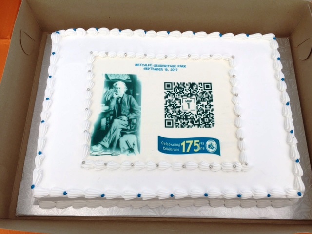
On Saturday, September 16, the new QR code system at Canada’s first municipal geoheritage park was inaugurated by Dr. Daniel Lebel, Director General of the Geological Survey of Canada (GSC). When it was founded in 1842, the Survey was one of the first government organizations of the United Province of Canada. Throughout its long and colourful history, Canada’s oldest scientific agency has played a leading role in exploring the nation.


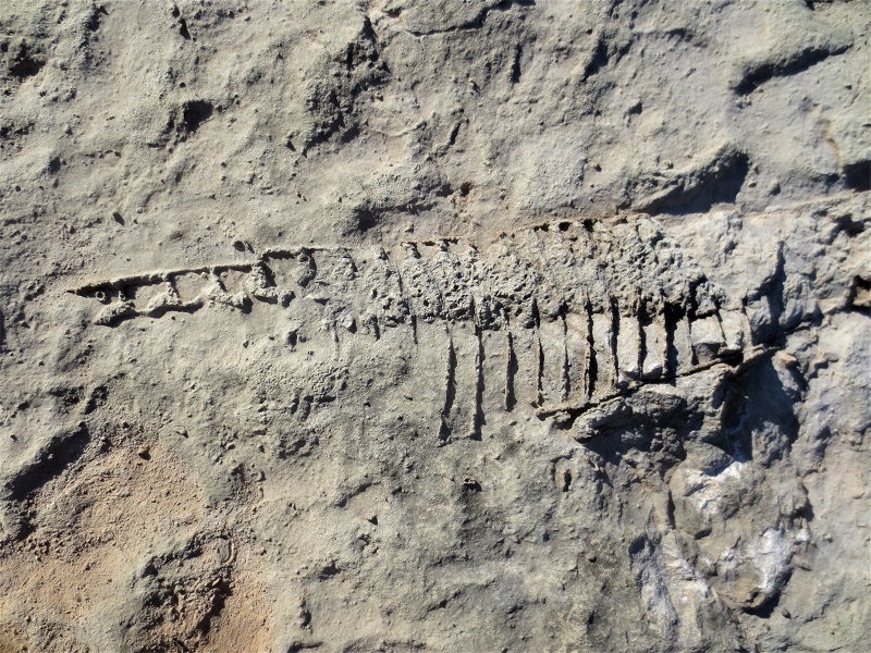
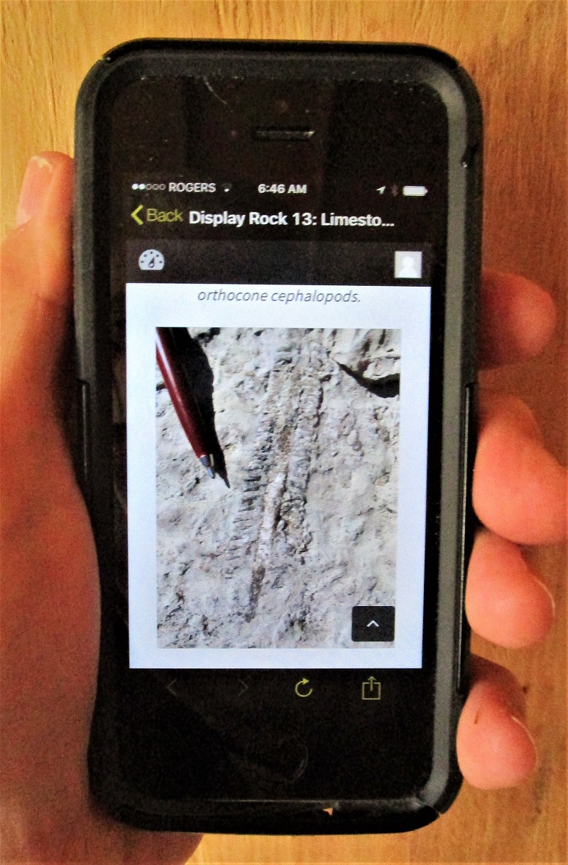
Dr. Lebel’s arrival by canoe in 1840s costume at Metcalfe Geoheritage Park (MGP) was a dramatization of a special visit by the GSC’s founder and legendary first Director, Sir William Logan (1798-1875). He was the first geologist to explore and describe the surroundings of the Mississippi River during his great expedition up the Ottawa Valley in 1845. Of the 45 boxes of geological material that Sir Logan shipped back to his Montreal headquarters, by steamboat, canoe, raft, and wagon, 5 were packed with rocks, minerals, fossils, and water samples that he collected during his explorations at Pakenham. His field notes of July 25, 1845, include sketches of limestone fossils he found there.
About 65 people were on hand to greet Dr. Lebel, and MGP volunteer Neil Carleton welcomed him at the shoreline with the presentation of an 1840s coin. Canada, he explained, was not yet a country during Sir Logan’s exploration of the Mississippi River, and coins in circulation at the time ranged from English shillings to a variety of trade tokens. He also thanked Sean Isaacs of Alliance Coin & Banknote in Almonte for his support towards the presentation.
The Master of Ceremonies for the event was Dr. Patricia Larkin, also a MGP Committee member. Larry McDermott, Shabot Obaadjiwan First Nation Ambassador, and Shaun McLaughlin, Mayor of Mississippi Mills, welcomed everyone to the event.
The QR code system of display signs and accompanying web pages was funded by a grant from the APGO Education Foundation. https://www.apgoedfoundation.ca/uploaded/ed-fund-files/pr-metcalfe-geoheritage-park-aug-2017.pdf In his remarks, Foundation Chair Dr. Bill Pearson noted that MGP is not only the first municipal geoheritage park in Canada, but is now the most technologically advanced. The website was designed and built by Brent Eades Web Communications of Almonte, and Silver Shingle of Lanark Highlands designed, produced, and installed the QR code signs. The content of the web pages was prepared by volunteers of the Association of Professional Geoscientists of Ontario, and the Metcalfe Geoheritage Park Committee.

Dr. Daniel Lebel spoke about the 175 year history of the GSC, and read from the detailed field notes that Sir Logan made during his 1845 explorations at the village of Pakenham, just 14 km downriver. He also spoke about the Survey’s important role today – sustainable development of Canada’s resources – environmental stewardship – management of natural geological and related hazards – technology innovation. Dr. Lebel noted too that Canada is home to the world’s oldest rocks, formed between 4.2 and 4.3 billion years ago.
The development of MGP and the QR code system has been a remarkable team effort. Thank you gifts of special rock slices were presented by Neil Carleton at the event, or later delivered, to:
- Dr. Daniel Lebel, Director General, Geological Survey of Canada;
- Dr. Bill Pearson, Chair, APGO Education Foundation;
- Shaun McLaughlin, Mayor, Mississippi Mills;
- Paul Virgin, President, Mississippi River Power Corp.;
- Dr. Al Donaldson, Professor Emeritus, Carleton University;
- Dr. Patricia Larkin, Metcalfe Geoheritage Park Committee;
- Calvin Murphy, Metcalfe Geoheritage Park Committee;
- Scott Newton, Metcalfe Geoheritage Park Committee.
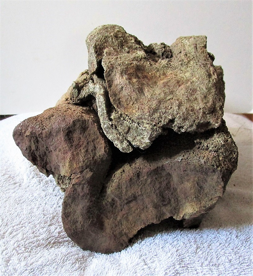

Three large samples of folded, calc-silicate-marble from west of Almonte were carefully cut into slices and polished with expert hands at the GSC’s headquarters in Ottawa. This special behind-the-scene project was made possible by Dr. Jeanne Percival, Head of Mineralogy, and Jacques Pinard at the Lapidary Lab. The rough rocks were transformed to reveal the internal details of metamorphic mineralization and complex folding that occurred deep in the roots of the world’s greatest mountain chain. The rocks were created about a billion years ago from sedimentary limestone containing silicate minerals. The mountains have eroded away and their ancient roots are now exposed at the Earth’s surface. Locally this is the familiar rolling hills landscape of the Canadian Shield across Lanark County.

