
Editor’s Note: I posted this item six years ago, when we had many fewer readers. I thought I’d repost it for folks who wouldn’t have seen it back then.
by Brent Eades
I’ve long enjoyed old maps and the stories they tell. I recently came across an online trove of high-resolution historic maps, the David Rumsey Map Collection. It’s an extraordinary resource for both historians and cartography fans, and contains over 36,000 digitized maps, the majority depicting North and South America.
Here’s a look at how Almonte has appeared on those maps over the past nearly two centuries.
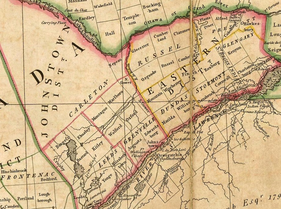
1818
In 1818 there was no Almonte, no Lanark County, and for that matter no Ottawa, which consisted then of a scattering of settlers’ farms. However, the area that would encompass Almonte had been surveyed by 1816, and the first European settler would arrive here within about two years.
1831
This map is from a London-published volume with the delightful title of:
To His most Excellent Majesty King William IVth. This Map of the Provinces of Lower & Upper Canada, Nova Scotia, New Brunswick, Newfoundland & Prince Edward Island, With A Large Section Of The United States, Compiled from the latest & most approved Astronomical observations, Authorities & recent Surveys.
It shows Almonte as ‘Shepherds Falls’, named for the area’s first settler, David Shepherd (or Shepperd or Sheppard.) He was granted a land patent here in about 1820 and built a sawmill, which apparently burned down soon after. The patent was sold to Daniel Shipman by about 1821, and the settlement became known as Shipman’s Mills.
Note that Carleton Place is simply ‘Carleton’, and that ‘By Town’ has been founded at the site of Ottawa. Appleton is ‘Apple Tree Falls’, its original name. Franktown appears to the south, as ‘Frank T’. Main roads are shown. There are no railways in Canada yet.
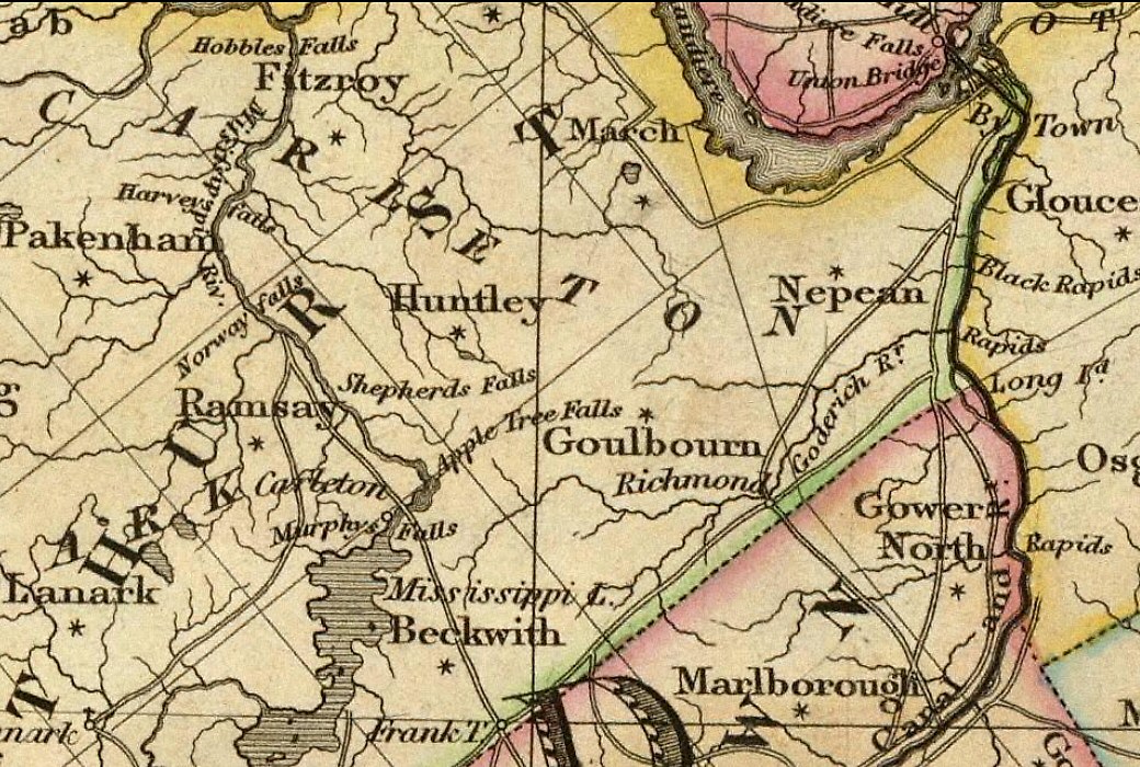
1832
This next map, published by the ‘Society for the Diffusion of Useful Knowledge’ in London, shows the Sheppard spelling.
But it also shows us in the wrong place; it has ‘Sheppards Mill’ where Pakenham is, and Almonte is identified as ‘Shipton’s Mill’. This is clearly an error.
Note the ‘proposed canal’ running south from Bytown. The canal was in fact finished by this time.

1845
This map was published by a German firm. We’re still ‘Shipton’s Mill’, an error that was perpetuated on numerous maps during this time. (Plagiarism among map-makers has been an issue for centuries; a common deterrent is the insertion of deliberate errors into maps, known as copyright traps.)
No Pakenham town yet, and no railway — the Brockville & Ottawa line would reach town from Smiths Falls in 1859.
The Goodwood River in time became the Jock.

1859
By 1859 we had formally changed the name of our town to Almonte, in honour of this fine gentleman. So how do we appear on this 1859 map?
Well — we don’t actually. Published by the Charles Desilver firm in Philadelphia, this one missed us entirely.

1883
This 1883 map, published in London by Letts, Son & Co, is noteworthy for the number of things it gets wrong. It has us in the right place but with an accent, Almonté. It also shows Carlton Place, Ennisville, Rossetta, Frankton, Barritts Rapids, Smith Falls and Gloster (all spelled wrong), and ‘Bellamyville’ where Clayton is now; it was never called that, although it was ‘Bellamy’s Mills’ for a number of years.
The railway ran through town by then. Letts & Co did get that right.
By the way, there is still a Letts company in London, which publishes maps among other things. Almost certainly the same.
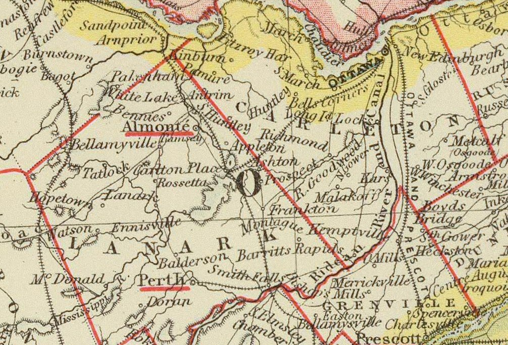
1906
Both Snedden and Blakeney appear on this 1906 Rand-McNally map. (Blakeney is another community whose name shifted over the years, being previously called ‘Snedden’s Mills’ and then ‘Rosebank’.)
Carleton Place is shown as ‘Carleton Jc. or Carleton Place P.O.’
To the east of Almonte is a village named ‘McKinlay’, which I can find no record of anywhere.

1927
By the 1920s ‘motoring’ had become the next big thing, and maps for motorists began to appear. This Rand-McNally Junior Auto Trails map shows the presumably car-worthy roads around Almonte in 1927.
There is no Highway 7 yet — it wouldn’t be completed through Carleton Place until about 1932. But Highway 17 is recognizable, as is what would become Highway 44 from Almonte to Carp. The latter was mostly gravel then; it was fully paved by 1951.

Here’s the legend for the above map. “Improved” roads might have been surfaced with tar or dressed gravel, but not asphalt.
