
by Ted Legg
 My wife and I attended the Mississippi Mills Council meeting last Wednesday (November 12th). We went there primarily to listen to the reasons why the TYPS (Take Young People Seriously) Youth Centre had closed down so abruptly. We however decided to stay and listen to Dr. Tineke Kuiper (PhD), from the Mississippi Valley Field Naturalists (MVFN), give a presentation on the reasons why development should not proceed in our Burnt Lands. After all, we thought, what is so special about this place. Surely it is just a scrubby, bare piece of land on which there had been some fires in the past. Well imagine our surprise when we found out that our (Yes, our) Burnt Lands was in fact an Alvar – and a global (Yes, global) rarity to boot.
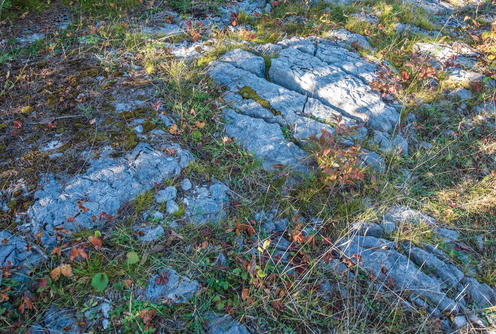
What’s an alvar? They are naturally open areas of thin soil lying over flat limestone or dolostone. The vegetation is generally sparse and is usually dominated by shrubs and native herbaceous vegetation. Trees seldom grow in these habitats because of the restricted soil available and because of drought conditions during the growing season. When trees are present, they can be found in the deeper and wider cracks in the bedrock where soil has accumulated over time.
This limestone was denuded by glaciation and the areas were subsequently maintained as natural openings by a variety of environmental factors including 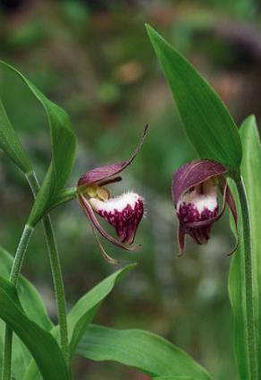 the lack of soil, fires, grazing by large herbivores and a pattern of flood-drought-flood experienced during different seasons. (Note: Alvar plateaus are usually higher than surrounding areas, thus are more denuded than the surrounding lower areas. As we drive along the March Road from Almonte to Ottawa or in the reverse direction, we have to drive uphill on either side to get up to the Burnt Lands.)
Alvar communities are found in the Baltic region on islands in southwestern Sweden, in Estonia and in a small area in western Russia; in fact, the word alvar has long been applied in the Baltic Sea Region and was first used in North America in the late 1960’s to define a similar type of habitat found only around the Great Lakes. You can go to this Wikipedia website to find other such locations around the world: http://en.wikipedia.org/wiki/Alvar
The number of actual (individual) alvar sites known in the Great Lakes region is estimated to be between only 250 and 300, concentrated in southern Ontario, but also found in New York, Michigan, Vermont and Ohio. Six main alvar regions are recognised in Ontario: Manitoulin Island, the Bruce Peninsula, the Carden Plains, the Smith Falls Plains, the Napanee Plains and Western Lake Erie (Pelee Island). In our area, these alvars evolved about 10,000 years ago as the Champlain Sea was retreating.
 Our Burnt Lands alvar (part of the Smith Falls Plains) is the best example of an alvar in the district and contains a rich and diverse flora supporting many provincially and regionally significant species; indeed our Burnt Lands Alvar has been rated as the fourth best alvar in the whole of North America. The vegetation is a complex mosaic of alvar, mixed and coniferous forest. The alvar vegetation consists of areas of bare exposed rock flats with plants generally occurring in minimal soil restricted to cracks and small low pockets. The mixed and coniferous forest associations are dominated by Cedar, White Spruce, Balsam Fir, and Poplar. Occasional small wetlands are to be found and most relate to present or past beaver activity.
Our Burnt Lands alvar straddles our border with Ottawa and is located on both sides of the March Road. It probably obtained its name from one of the forest fires that swept the area during early European settlement. It is possible that fires assist in creating or maintaining alvars. However, the shallow soil, with alternating drought and flooding, is likely the main factor. The main point is that in a land that is typically covered in forest, alvars provide small areas of open prairie-like conditions for plants that have adapted to such conditions.
Our Burnt Lands has some of the most extensive and diverse alvar communities in all of Ontario. Located just north of Carleton Place and west of Ottawa,  our Burnt Lands alvar supports 82 breeding bird species, 48 butterfly species and 98 owlet moth species. Some of the distinctive plants include Cooper’s milk vetch and Ram’s-head Lady Slipper. It is an outstanding example of a globally-threatened alvar habitat – combining alvar grasslands, shrub lands, forests and wetlands. And our alvar is thought to have existed in some form since the end of the last ice age because it has globally rare snails, other globally rare invertebrates and even a kind of carabid beetle found nowhere else in the world. Recently a little orchid was found. It is believed that it may have lain dormant for years and only came to life as a result of the three-month drought that we experienced two years ago. Such are the wonders of our alvar!!!
Our Burnt Lands alvar is the best example of this habitat type in Lanark County and in the whole of eastern Ontario. It has been the subject of numerous scientific studies. Because of its significance, the Ontario Ministry of Natural Resources has designated some 1,500 hectares of the alvar as an Area of Natural and Scientific Interest (ANSI). A smaller parcel of several hundred hectares is protected within the Burnt Lands Provincial Park (Nature Reserve). (PS: An Area of Natural and Scientific Interest (or ANSI) is an official designation by the provincial Government of Ontario in Canada applied to contiguous geographical regions within the province that have geological or ecological features which are significantly representative provincially, regionally, or locally. Furthermore, the word ‘contiguous’ is also important in that it implies a ‘joining’ and/or the ability to ‘move and/or flow’ from one area to another.)
 Threats to the alvar include urban sprawl, subdivisions, quarries, illegal dumping of household trash and construction materials, illegal sand quarrying, and all-terrain vehicles. There is also a problem with jack pine trees, once mistakenly planted by the Ontario Ministry of Natural Resources, that are now shading out some of the rare plant species. Some experts are now suggesting that these mis-planted trees need to be removed. A fire in 1999 removed some of the encroaching forest and produced open meadows, which, in 2008, had nearly twice the number of plant species as in adjoining unburned areas. And given that the flora and the fauna of these alvars seem to move around (albeit at Darwenianly-glacial speeds), sub-divisions and development that block their paths do so at the peril of this global rarity – our Burnt Lands Alvar.
And lastly, it is a popular destination with naturalists, including bird-watchers and photographers – all part of our tourist-attracting assets in Mississippi Mills.
So the question is: Since there is now a proposal to build on our Burnt Lands, should development really take place in such an ecologically-sensitive area or should it remain protected and nurtured as the Province intended when it set aside this area as an ANSI in 1983?
And if the above strikes a responsive chord, please let your councillors and others know that our Burnt Lands alvar is indeed very special, is globally unique, and is much more than just a pile of rocks. As such, it is particularly very important that we take good care of and respect our Burnt Lands alvar – this natural treasure that has been bequeath to us down through the ages.
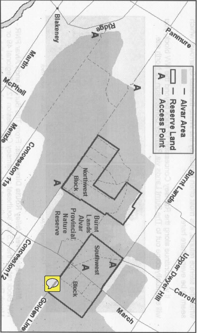
Below see a Google Map of the Burnt Lands with the proposed location of the cluster lot starred.
