
Locating Objects in Night Sky Constellations
How do we refer to celestial objects in the sky?
-
- We know they are projected unto our Celestial Sphere.
- We see patterns of stars forming constellations that serve as ‘starhop’ locations.
- However, over the course of a month, the same constellation (and the stars, clusters, and galaxies within those bounds) will rise 2 hours earlier by the end of the month.
Constellation Patterns- Orienting yourself on your Local Horizon
These patterns form a schematic skymap using bright stars forming familiar outlines.
For observers in the Northern Hemisphere: start with the northerly constellation, the Big Dipper and point to various other “skymarks” – Polaris (closest to the North Celestial Pole).
- Summer/Fall: find the Summer Triangle, Great Square of Pegasus
- Fall Winter:Auriga, Castor and Pollux of Gemini
- Spring: Leo and Virgo (Spica)
- Circumpolar (Cassiopeia and the Big Dipper)

Local Horizon System – Altitude-Azimuth Coordinates
-
-
- Earth based reference
- Altitude is the vertical angle from horizon
- Azimuth is the horizontal angle around the horizon with 0 as the geographic north
- Good for locating objects relative to current location and time – that’s how we use our planisphere
-
SkyMap System – Celestial Coordinates
-
- Declination is the celestial ‘latitude’ (or altitude) in the sky
- Right Ascension is the celestial ‘longitude’ (or azimuth)in the sky
- Good for location objects on a Star Chart
- This is how we permanently locate objects on the Celestial Sphere, (i.e. star, star cluster, galaxy) location in our Night Sky …
- Alt-Az coordinates of celestial objects change with time and location – they are just transitory locations above our horizon.
- Celestial Coordinates are used for locating stars on a fixed map.
Celestial Coordinates – Mapping Stars to their fixed Locations
Objects on the Celestial Sphere have fixed coordinates in terms of DEC,RA. This is similar to our fixed location on earth in LAT,LONG.

What we see in the sky depends on where and when…
WHERE: Latitude of the Observer – This sets the plane of the horizon. Here are 2 illustrations showing why the pole star is not at our zenith but rather at our latitude. This explains why polar alignment requires that the wedge of the equatorial mount must be set to the observer’s latitude.
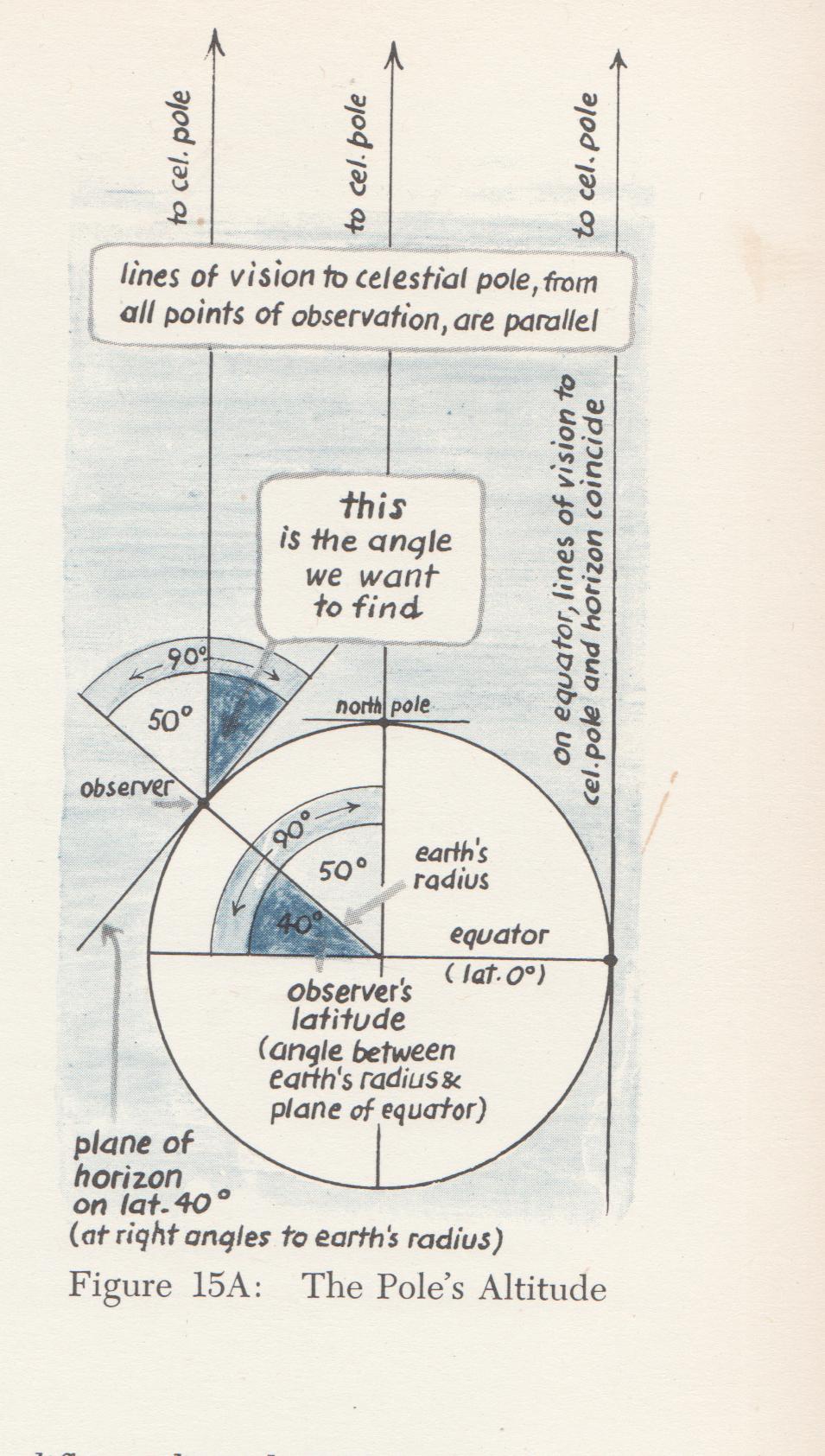
The altitude of Polaris is the same as our latitude – roughly 45 degrees; Observers at different latitudes have different North/South boundaries of the celestial sky that they can see. Here’s a sketch showing two parallel lines cut by the transversal that makes the latitude angle to the equator.

Plane of Observers Horizon:The further north we are,the less southern sky we see!
-Click on the animation courtesy P. Browne (Geogebra)

Celestial Coordinates – Right Ascension and Declination.
For a given time of year, the Right Ascension and Declination of a Star will transit along the South Meridian. These coordinates are very similar to the earth coordinate system:
Location of Stars by Right Ascension and Declination
- Shown below, the stars Aldebaran and Sirius have fixed Right Ascension and Declination
As we orbit the sun, we see different sections of sky, different constellations when the sun is below the horizon.
What line is our Local Meridian?
It is the line along the great circle perpendicular to our celestial equator that starts due North at the horizon, then rises up and crosses the Zenith and touches down directly South at our local horizon. Because the meridian is fixed to the local horizon, a celestial object (star, planet, sun) will cross our meridian as the Earth spins.

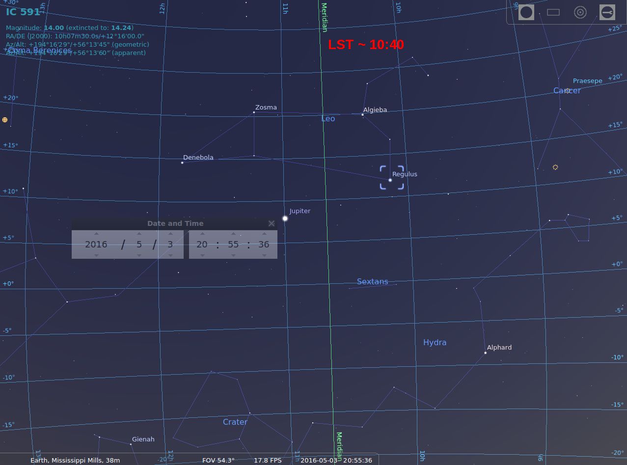 Our Local Meridian Right Ascension Value at 20:55pm EDT on May 2 was roughly 10:40. This is called our Local Sidereal Time. Constellations and the celestial objects located within them culminate (reach their highest point) along our meridian. As the earth turns, the stars rise from the East.
 Click here to see the animation.
The sky map is divided into 24 bands from left-to-right . It takes approximately 1 hour for each of them to move a distance equal to its width across the sky. So each object is at certain point in (RA, Dec) and would appear at a certain “hour angle”. In other words, if you stood outside and looked at the sky for several hours you would see the stars seem to move across your Meridian from East to West at that rate.
The Local Sidereal Time is simply the Right Ascension value of the Meridian Line. When we consider what objects are due south along our meridian, we think of the Hour Angle relative to our meridian Line.
Here’s an easy way to remember Hour Angles:
Hour Angle = Local Sidereal Time – Right Ascension (of the Object)
Example: In our example LST = 10:40 and we notice that Regulus is at RA 10:08
Hour Angle = 10:40 – 10:08 or 32 minutes off our meridian.
Summary
- The Right Ascension of our Meridian at any Time is called the Local Sidereal Time. This corresponds to an Hour Angle of 0 degrees. Stars East or West of our LST (our Meridian) have Positive (E) or Negative(W) Hour Angles representing the angular distance off our local meridian.
- For a really complete guide to Right Ascension and Declination – visit our Calgary RASC site: http://calgary.rasc.ca/radecl.htm
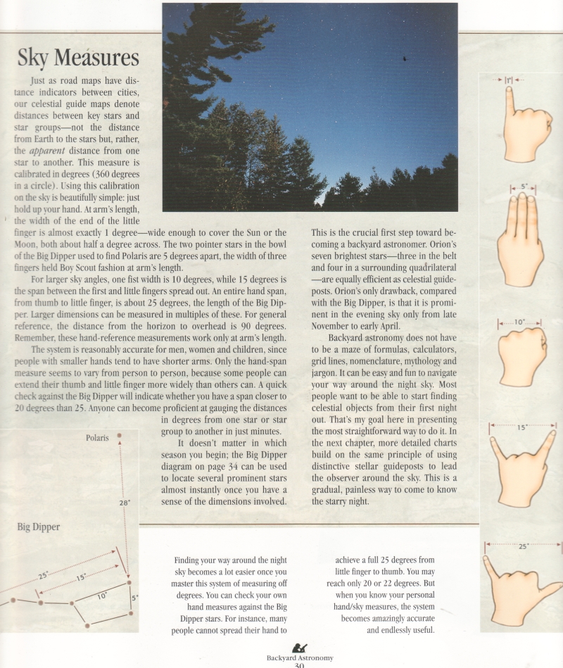
Angles in the Sky
Here is a star chart produced by SkyMap (Chris Marriott). Notice also the Scale beneath. We see 15 degrees in sky angle.
Since we are looking through our Celestial Sphere, we are measuring angles.
 We can measure smaller angles, and these help us identify proximity of stars to each other with respect to our line of sight.
Sidereal (or Star) Time –Sidereal Time – How long is a Day?
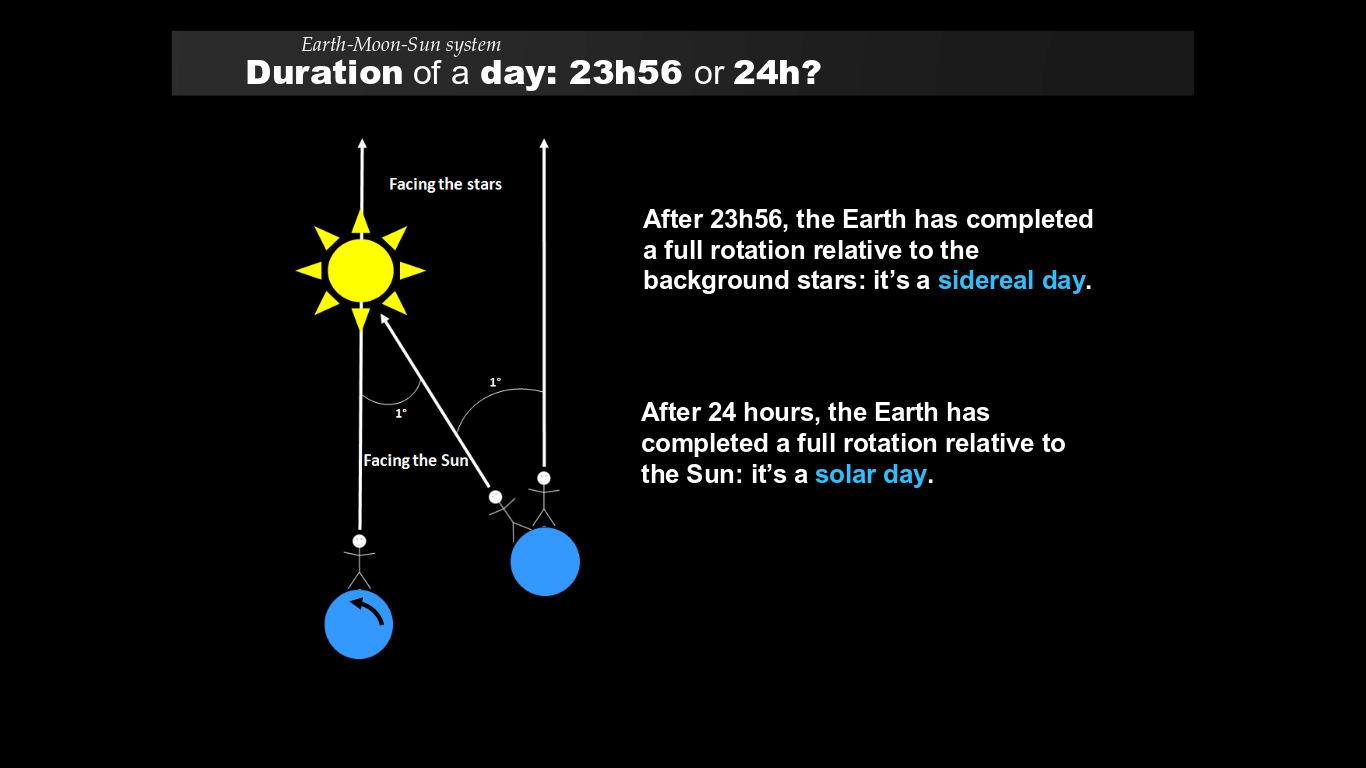
A Day On Earth using Star Time
Stars have fixed locations on the celestial sphere, but due to the Earth’s rotation they rotate 15 degrees per hour
Sidereal Time = Hour and Day with respect to the Stars..(not the Sun)
- 1 Day = 1/365th of a circle about one degree
around the Sun. - Earth rotates on its axis as well as rotating around the sun.
- So, the time for a star to return to the same place in our sky the following evening is only 23 hours, 56 minutes and 4 seconds (not 24 hours)
This is called a Sidereal Day. It measures both Earth Rotation and Orbit with respect to the stars
Understanding Star Time Interval between Sidereal Days

- Point A on the second day is still looking at a parallel direction in space .
- However the star will appear at that spot in the sky 4 minutes of earth time earlier.
- Rotation taken up by 1440 (minutes/day) as the fraction 1/365 (orbit/day) So 1440/365 is roughly 4 minutes (shorter)
- Spin around as we revolve…to reach the same position toward the stars at a fixed infinite distance…then we spin around a bit further towards the center of our orbit…towards the sun.
The stars rise 4 minutes earlier each day because the earth has also moved through its orbit as it has rotated around from night to day to night. So now we see why Leo will rise 2 hours earlier at the end of the month: 4 mins x 30 days = 120 minutes or 2 hours.
 Leo is an early Spring constellation and will rise and set earlier each night . In later spring, these stars will eventually set while it is still daylight.Constellation Leo will be followed by the summer constellation of Lyra (which contains the bright star Vega).
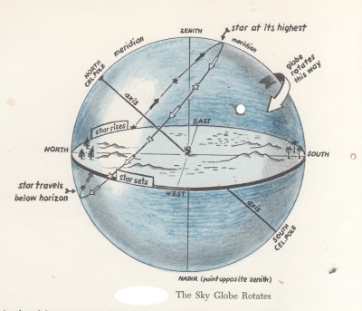
Celestial Objects rise in the East and set in the West
Apparent Motion of the Sky: Every night, stars rise and set… just as every day, the Sun, our star rises and sets… Because the Earth is turning and carrying the observer from West to East, the stars seem to be moving from East to West. What we see in the sky changes all the time because the earth is always rotating.
The Sun in the morning appears to rise in the East, At noon, it appears in the South (for our latitude) part of the sky. In the evening it is seen setting in the West.
- Similarly, you can see a bright star rise above the eastern
horizon in the early part of the night. At about midnight (middle of
the night ~ high noon for day) the star culminates. (rises highest)
in the southern part of the sky. When the night ends, and morning is
coming, the star will be setting in the western part of the sky. - The motion of the sky is called the apparent motion of the
sky because it is really we on the surface of the earth who are
rotating in this way.
Star Positions throughout the Evening for a given Latitude
- Star A could be a star in the Big Dipper
- Star B and C will eventually set below the horizon.
- Some Objects never rise above our Local Horizon as in (a)
It all
depends on where you, the Observer are standing on the earth.

Star Motion – Image courtesy: http://cseligman.com/text/sky/motions.html
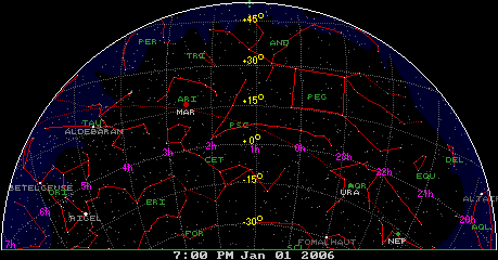
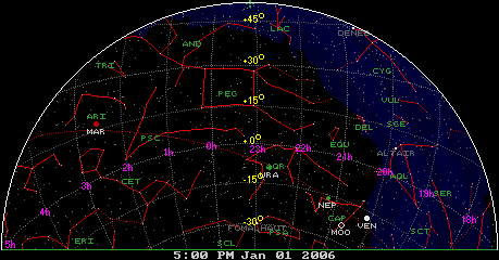
 Using Detailed Star Maps
If you are not using the adjustable planisphere or a planetarium program, and just want to observe with star maps, you will need to use more than one over the course of the evening . Leo Enright has provided 6 star maps in The Beginning Observer’s Guide that show the sky for two months as a time. The one above is Map 3
For more detailed star maps, use maps that show details of areas. Here we see the fixed coordinates representing the position of the objects. One example is the Pocket Sky Atlas shown below::
