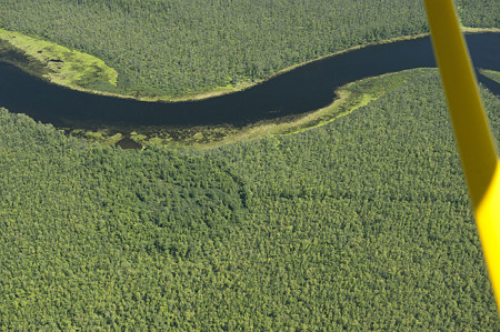
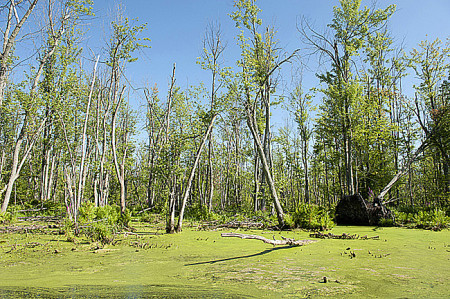
The Appleton Wetland;
Its Decline, Cause and Recommended Action
Executive Summary
Report prepared by
Appleton Wetland Research Group
of the
Mississippi Valley Field Naturalists
Research Group Members:
Cliff Bennett, Chair
Joachim Moenig
Al Seaman
Mike O’Malley
Howard Robinson
August 11, 2014
Executive Summary

This report is the end result of an investigation by a Research Group of the Mississippi Valley Field Naturalists (MVFN) into the causes of a large scale die-off of soft maple trees in the Appleton Wetland (a Provincially Significant Wetland). The problem is associated with a change in water levels on the portion of the Mississippi River between Appleton and Almonte. Since 2006, the water levels on the Mississippi River have been formally regulated by the Mississippi River Water Management Plan (MRWMP), including this stretch of the river, identified in the plan as Reach 18. The generator station (GS) at the bottom of Reach 18 is operated by Enerdu Power Systems Inc., and the company appears to be operating in accord with the MRWMP terms that apply to the GS. Although it is clear that water levels in Almonte have increased since their facility operated originally as a flour mill, the exact timing of that change was not certain, nor was there any real understanding of what effect the Almonte water level changes had on water levels in the Appleton Wetland. What is known for certain is that the maple trees in the Appleton Wetland were dying massively by 2006, and there are photographs and complaints that attest to that.

The maple species involved are known to be well adapted to life in a wooded swamp such as the Appleton Wetland. They are very flood tolerant on both a seasonal basis and for longer periods. High spring floods, and elevated water levels through the late fall and winter are not a problem, and they will also tolerate continuous inundation for up to two years. What these trees must have for healthy growth is a substantial period through most summers where the water level in the adjacent river is at least 25 cm below the surface of the ground where the maples are growing.
Before this project started there were several popular opinions as to what caused the tree die-off. These included;
- onset of tree diseases or attacks by insects,
- increase in flow rates of the Mississippi River in the last decade causing a rise in water level,
- adverse effects of toxic waste that spilled from the nearby Appletex lagoon in the fall of 1989 and the spring of 1990, and
- increased summer water levels in the wetland associated with the Enerdu operations.
There was no evidence from the Ministry of Natural Resources (MNR), the Mississippi Valley Conservation Authority (MVCA), or other sources, to support the first three of those possibilities. They were dismissed by the research team as very improbable early in the investigation based on known information. That left the last item as a most probable cause, and the focus of the Research Group’s work. The task of the Research Group was to eliminate any coincidental associations and to discover the real cause and effect relationships along with quantifiable evidence to support any conclusions.
The Research Group started by collecting known information that might have some bearing on river water levels at Almonte over the 1840 to 1989 period, termed the Flour Mill Era, and over the period from 1990 to the present termed the Generator Station Era.
During the Flour Mill Era there are no recorded measurements of river water levels in Almonte or Appleton that have survived. The research team has looked to other indirect evidence that
may provide some indication of past water level history. This included river flow rate data, written, photographic and anecdotal records of the weir and flashboards immediately above the Flour Mill, and the observations of water levels relative to known landmarks, the submerged rock ridge and the adjacent small island just above the Almonte Fair Grounds. It was concluded that for most summers the river level at Almonte was very close to 117.2 masl, the height of the concrete weir of the former Almonte Flour Mill.
Measureable data for the Generator Station Era, particularly during the last decade, is more accessible. Photographic records show that flashboard height on the weir was increased to 117.7 masl in 2001, or possibly a few years earlier, and direct observation demonstrates that water usage is now controlled to maintain water levels between 117.7 and 117.5 masl throughout the low-flow summer period.

In 2006, the MRWMP went into effect. The water level limits in the plan set for Enerdu simply endorsed what they were already doing. Although the plan did recognize the existence of the Appleton Wetland, and clearly indicates that ecological integrity has a higher priority than power generation, it failed to appreciate that the higher water levels allowed for Enerdu would kill the trees in the wetland. In 2006 large numbers of dead trees were already clearly visible in the wetland.
Also in 2006, the MVCA started recording water level data at the Bridge Street bridge in Almonte. This provided for the first time some much needed quantitative water level data, but it was limited to Almonte with no understanding of how it would apply to levels in Appleton.
The Research Group undertook several field projects in the summer and fall of 2013 to better understand the interaction between water level, flow rate and Enerdu operations. The first requirement was to establish an elevation benchmark at the shoreline of Appleton Bay accurately calibrated to the same CGVD28 standard used for the Almonte level measurements. The task was completed on October 11, 2013, and enabled real Appleton to Almonte elevation comparison.
In the summer of 2011, MVFN undertook a “Tree Project” that simultaneously measured water levels in Almonte and relative water levels at six trees along the shoreline in the Appleton Wetland. It showed a clear association of water level changes at both ends of Reach 18. With the 2013 elevation calibration applied to the prior 2011 data, the level relationship became much clearer. With all flashboards in place on the weir, and with summer flow below 10 cms, the river was flat, with Appleton at the same level as Almonte. That is, at 117.7 masl or somewhat below. The project also led to the conclusion that the optimum summer water level in Appleton for healthy tree growth should be maintained below 117.4 masl.
From August 4 to November 17 in 2013 a series of simultaneous water level measurements were conducted at Almonte and Appleton. The results prove that the presence of flashboards at Almonte is the primary cause of high summer water levels in the wetland. River flow rate is a secondary factor and some data over a limited range of flow rates was acquired.
An investigation of the wetland was conducted in November 2013 to get a better view of interior conditions. Observations of tree health combined with ground level and water level at a number of locations were made. The conclusion was that water levels are too high and that a summer level of 117.4 masl would be needed for healthy tree growth.
A further project in the spring of 2014 made simultaneous level measurements at four locations along the river from immediately above the Almonte weir to Appleton Bay starting just before the peak of the flood, and after all flashboards had been swept away, until June 19. This data provides a set of charts with flow versus level curves for four locations, with a measured flow range from 35.5 to 244 cms for the no flashboards case. We now have some very useful data on flow versus level relationships. In particular, it is now possible to take the Flour Mill Era probable summer level in Almonte of 117.2 masl, along with the historic mean summer flow of 10 cms, and compute the corresponding level in Appleton as 117.4 masl. This is a good estimate for the previously unrecorded historic summer water level in the Appleton Wetland.
This estimate is a significant result. Two separate sets of field observations in the wetland have produced 117.4 masl as the right level for healthy tree growth, and the derived historic level has turned out to be the same level.
The research results confirm that excessive water levels resulting from Enerdu’s operations, which conform to the existing MRWMP, are causing the die-off of the soft maples in the wetland. In effect, the trees are drowning. The Enerdu operational limits in the MRWMP clearly do not conform to the priorities of the plan that rank ecological integrity above power generation. Thus an amendment to the MRWMP is needed immediately.
We recommend that:
1. The MRWMP be amended immediately for Reach 18 to set the level of 117.4 masl, as measured at Appleton, as the maximum operational summer water level from May 1 to October 31.
2. The amendment provisions must include a five year test period during which the conditions in the Appleton Wetland must be monitored closely for signs of tree recovery and for evidence that 117.4 masl is a valid operational summer water level, with the option of adjusting water levels in the remainder of the test period if warranted.
3. A further amendment provision must include a thorough evaluation of results at the end of the test period to establish a final Water Management Plan for Reach 18.
4. Approval of the current upgrade plan of Enerdu must be delayed until the recommended MRWMP amendment has been resolved..
Read the full report here 1-CopyrightNotice 2-PreliminaryReport 2014-03-11 3-CoverLtr 4-ExecutiveSummary 5-FinalWetlandReport AppendixA-Definitions AppendixB-Extracts-MRWMP AppendixC-FlowRec AppendixD-LevelRec AppendixE-PhotoAnal AppendixF-AppletonLevelRef AppendixG-MVFN-TreeProj AppendixH-CoordinatedLevMeas AppendixI-RockRidge AppendixJ-Island AppendixK-WetlandInspect AppendixL-TreeCoring AppendixM-SAC-Min AppendixN-PSW-ANSI AppendixO-WetlandPhotos AppendixP-MoreFlow-Level AppendixQ-MVCA-report
The Almonte branch of the Mississippi Mills Public Library now has a printed copy of the report and all appendices. It is available for reference at the library.

